-
Atlantic Ocean: The Atlantic Ocean, 1787, Thomas Jefferys auth.
Regular price $45.00 CADRegular price -
Atlantic Ocean: A Chart of the Atlantic Ocean, 1775, Sayer auth.
Regular price $45.00 CADRegular price -
Atlantic Ocean: A Chart of the North Atlantic, 1907
Regular price $45.00 CADRegular price -
Atlantic Ocean: A Geological Map of Iceland, In High Relief
Regular price $45.00 CADRegular price -
Atlantic Ocean: Bellin, Carte Reduite de l'Ocean Occidental, 1744
Regular price $45.00 CADRegular price -
Atlantic Ocean: Chart of the Atlantic Ocean showing Europe and Africa, the eastern half of North America,1569
Regular price $45.00 CADRegular price -
Atlantic Ocean: Chart of the Atlantic Ocean, with the British, French, & Spanish settlements in North America, and the West Indies, as also on the coast of Africa, 1768, Green
Regular price $45.00 CADRegular price -
Atlantic Ocean: Frederic, Anglo-French naval encounters in 1758
Regular price $45.00 CADRegular price -
Atlantic Ocean: Greenland: Gronlandia Antiqua Secundum utramque partem Orientalem & Occidentalem, 1741
Regular price $45.00 CADRegular price -
Atlantic Ocean: Greenland: Tabula Nautica qua repraesentatur orae maritimae, meatus, ac freta, noviter a Hudsono Anglo ad Caurum supra Novam Franciam indagata,1612
Regular price $75.00 CADRegular price -
Atlantic Ocean: Iceland, Tabula Islandiæ, 1665, Blaeu auth.
Regular price $45.00 CADRegular price -
Atlantic Ocean: Iceland, Theatrum Orbis Terrarum, 1590, Ortelius auth.
Regular price $45.00 CADRegular price -
Atlantic Ocean: Iceland.Coronelli, Vincenzo, Isola d' Islanda, 1697
Regular price $45.00 CADRegular price -
Atlantic Ocean: Islands in the Atlantic Ocean, 1740, Seutter auth.
Regular price $45.00 CADRegular price -
Atlantic Ocean: Jansson, Mar del Nort,1650
Regular price $45.00 CADRegular price -
Atlantic Ocean: Mare del Nord, 1693 Coronelli (Vicenzo 1650-1718)
Regular price $45.00 CADRegular price -
Atlantic Ocean: North Atlantic Ocean, 1763
Regular price $45.00 CADRegular price -
Atlantic Ocean: Ortelius, Abraham, Septentrionalivm regionvm descrip, (North Atlantic Region), 1560
Regular price $45.00 CADRegular price -
Atlantic Ocean: The Time & Tide Map of The Atlantic Charter,1942
Regular price $45.00 CADRegular price -
Atlantic Ocean: Zurla, Carta Da Navegar De Nicolo et Antonio Zeni Fvrono In Tramontana Lano M.CCC.LXXX(1380)
Regular price $45.00 CADRegular price -
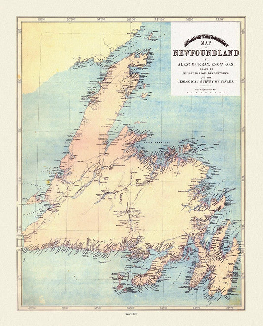
Atlas of the Dominion map of Newfoundland, Murray auth., 1875
Regular price $45.00 CADRegular price -
Atlas of the Dominion map of Newfoundland, Murray auth., 1875, map on heavy cotton canvas, 50 x 70 cm, 20 x 25" approx.
Regular price $45.00 CADRegular price -
Avro Arrow Canada, Aviation Poster, on heavy cotton canvas, 20 x 27" approx.
Regular price $45.00 CADRegular price -
Baffin Bay, Canada, 1776 Jefferys auth., map on heavy cotton canvas, 50 x 70cm, 20 x 25" approx.
Regular price $45.00 CADRegular price