-
North America: Virginia and Maryland, 1676, Speed authore
Regular price $45.00 CADRegular price -
North America: Virginia and Maryland, 1676, Speed authore
Regular price $45.00 CADRegular price -
North and South America ,1658, Walton auth.
Regular price $45.00 CADRegular price -
North and South America ,1658, Walton auth. map on durable cotton canvas, 50 x 70 cm, 20 x 25" approx.
Regular price $45.00 CADRegular price -
North and West Canada: British Columbia railway belt Sicamous sheet, west of sixth meridan map showing the disposition of lands, 1913
Regular price $45.00 CADRegular price -
North and West Canada: 1937 road map of British Columbia
Regular price $45.00 CADRegular price -
North and West Canada: A chart shewing part of the coast of N.W. America , with the tracks of His Majesty's sloop Discovery and armed tender Chatham, 1798
Regular price $45.00 CADRegular price -
North and West Canada: A Sketch Map of British Columbia in High Relief
Regular price $45.00 CADRegular price -
North and West Canada: A Sketch Map of British Columbia in High Relief
Regular price $45.00 CADRegular price -
North and West Canada: British Columbia, .1913, Cram auth.
Regular price $45.00 CADRegular price -
North Marysburgh Township, Prince Edward County, 1888, map on heavy cotton canvas, 45 x 65 cm, 18 x 24" approx.0
Regular price $45.00 CADRegular price -
North Pole, with the countries hitherto discovered situated near or adjacent to it as well as some others more remote.1747, canvas 20x25"
Regular price $45.00 CADRegular price -
North shore of Lake Huron compiled from map issued by the Dept. of Crown Lands and from rangers' maps,1888, 50 x 70 cm or 20x25" approx.
Regular price $45.00 CADRegular price -
North Shore, Lake Superior, Ontario, 1924, Map on heavy cotton canvas, 22x27" approx.
Regular price $45.00 CADRegular price -
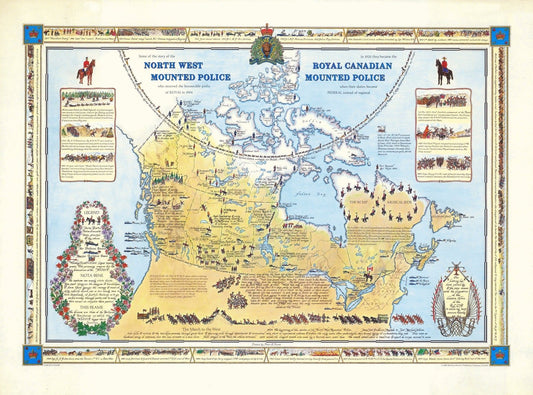
North West Mounted Police ( Royal Canadian Mounted Police), 1966, Poster on Heavy Cotton Canvas, Approx. 22x27"
Regular price $45.00 CADRegular price -
Northern Alberta land districts comprising agencies of Peace River, Grande Prairie, Edmonton showing homestead entry, 1919, canvas, 22x27"
Regular price $45.00 CADRegular price -
Northern Alberta, map showing disposition of lands, 1918 , map on heavy cotton canvas, 22x27" approx.
Regular price $45.00 CADRegular price -
Northern Alberta, map showing disposition of lands, 1918 South Sheet, map on heavy cotton canvas, 22x27" approx.
Regular price $45.00 CADRegular price -
Northern Alberta, Map showing wooded and prairie tracts, etc.,by J.B. Tyrrell, 1884 , map on heavy cotton canvas, 20x27" approx.
Regular price $45.00 CADRegular price -


Northern America, Arrowsmith auth., 1855, map on durable cotton canvas, 50 x 70 cm, 20 x 25" approx.
Regular price $45.00 CADRegular price -
Northern America. 1857, map on heavy cotton canvas, 20 x 25" approx.
Regular price $45.00 CADRegular price -
Northern Canada, 1907, map on heavy cotton canvas, 22x27" approx.
Regular price $45.00 CADRegular price -


Northern Manitoba, A Resource Map, 1922 , map on durable cotton canvas, 50 x 70 cm, 20 x 25" approx.
Regular price $45.00 CADRegular price -
Northern Michigan and Lake Superior, Rand McNally and Company, 1879 , map on heavy cotton canvas, 50 x 70 cm, 20 x 25" approx.
Regular price $45.00 CADRegular price