-
Asia: New Map of Great Tartary, and China, Wells auth., 1700
Regular price $45.00 CADRegular price -
Asia: Southeast: Insulae Indiae Orientalis. 1636. Mercator et al. auth.
Regular price $45.00 CADRegular price -
Asia: Southeast: A New Map of the East Indies, Wells auth, 1700
Regular price $45.00 CADRegular price -
Asia: Southeast: India Orientalis. 1636. Mercator et al. auth.
Regular price $45.00 CADRegular price -
Asia: Sri Lanka: Ceilan. 1636. Mercator et al. auth.
Regular price $45.00 CADRegular price -
Asia: Tartary, Tartaria, 1676, Speed authore
Regular price $45.00 CADRegular price -
Asia: Tartary, Tartaria, 1676, Speed authore
Regular price $45.00 CADRegular price -
Asia; China: A Chronological chart of Far Eastern History, 1949 19 x 54"
Regular price $120.00 CADRegular price -
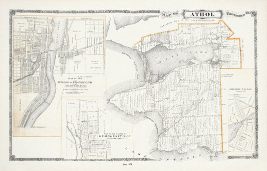
Athol Township, Ont., 1878, map on durable cotton canvas, 50 x 70 cm, 20 x 25" approx.
Regular price $45.00 CADRegular price -
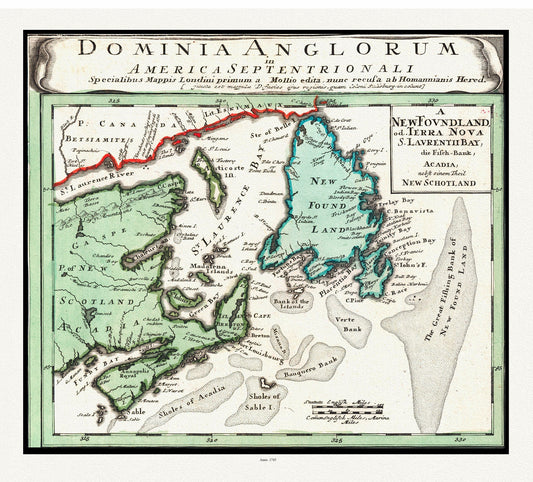
Atlantic Canada, Bellin auth., 1745 , map on heavy cotton canvas, 50 x 70cm, 20 x 25" approx.
Regular price $45.00 CADRegular price -
Atlantic Canada: A plan of the island of St. John with the divisions of the counties, parishes, & the lots as granted by government, likewise the soundings round the coast and harbours, 1775
Regular price $45.00 CADRegular price -
Atlantic Canada: Bellin, Jacques Nicolas, America Septentrionali ,1745
Regular price $45.00 CADRegular price -
Atlantic Canada: Bellin, Partie Orientale de la Nouvelle France ou du Canada, 1755
Regular price $45.00 CADRegular price -
Atlantic Canada: Bowen, A new & accurate map of the islands of Newfoundland, Cape Breton, St. John and Anticosta, together with the neighbouring countries of Nova Scotia, Canada, &c, 1752
Regular price $45.00 CADRegular price -
Atlantic Canada: Carte de la Nouvelle-France, 1632, Champlain auth.
Regular price $45.00 CADRegular price -
Atlantic Canada: Map 12, Prince County, Prince Edward Island, 1925 ( many more of these are available)
Regular price $45.00 CADRegular price -
Atlantic Canada: Nautical Chart, The Gulf of St. Lawrence. Sheet VIII, Western Part of Northumberland Strait, 1839
Regular price $45.00 CADRegular price -
Atlantic Canada: Popple, Part of a Map of the British Empire in America, 1733
Regular price $45.00 CADRegular price -
Atlantic Canada: Prince Edward Island,1964, Furse auth.
Regular price $45.00 CADRegular price -
Atlantic Canada: Province of Prince Edward Island, Canada, 1925
Regular price $45.00 CADRegular price -
Atlantic Canada: Relief Map of Atlantic Canada, 1924 Ver. III
Regular price $45.00 CADRegular price -
Atlantic Canada: Roe Brothers (Firm)-Atlas of the Maritime Provinces-Prince Co., P.E.I.,1878
Regular price $45.00 CADRegular price